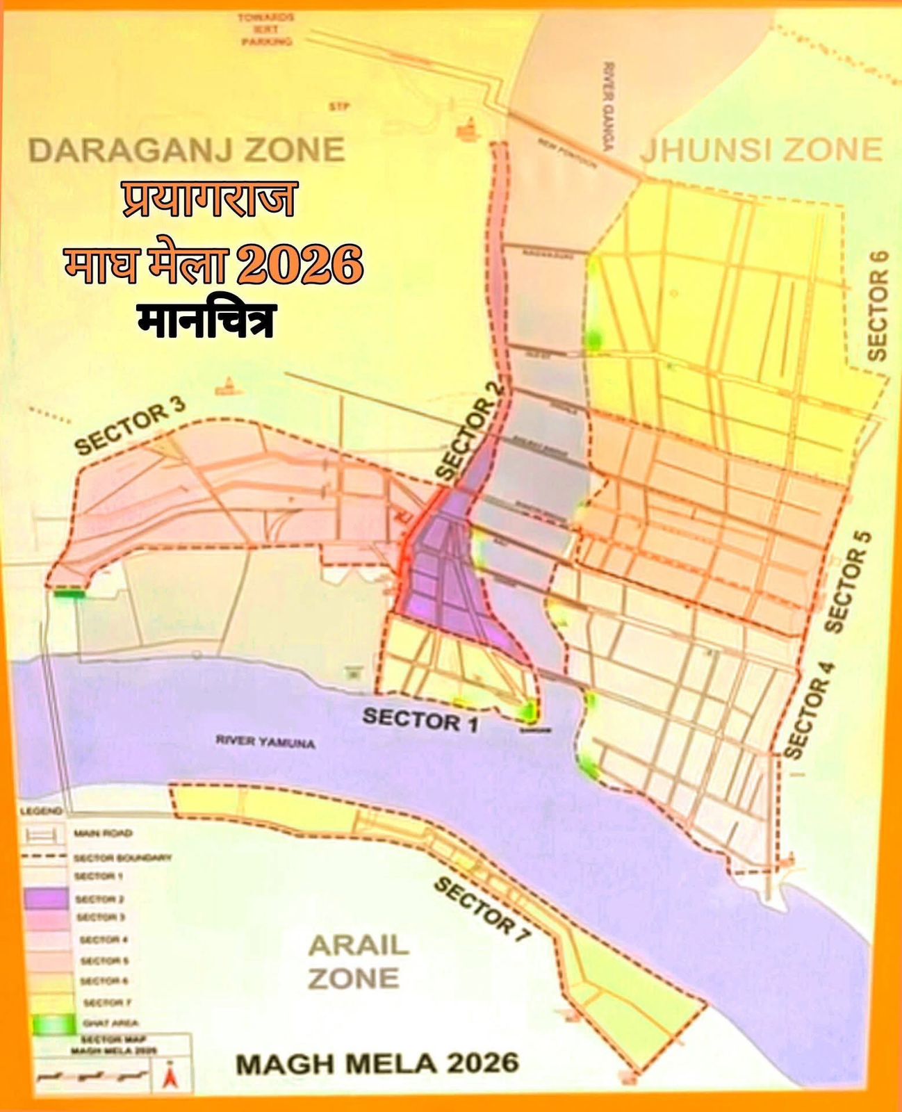
Magh Mela Map 2026 – Complete Guide for Pilgrims & Visitors
The Magh Mela Map 2026 is an essential guide for devotees, tourists, and Kalpvasis visiting Magh Mela at Prayagraj.
Held every year during the holy month of Magh (January–February), Magh Mela attracts lakhs of pilgrims to the sacred Triveni Sangam.
This blog will help you understand the Magh Mela 2026 map, including sectors, ghats, routes, facilities, and important locations—so your yatra remains smooth and peaceful.

What is Magh Mela Map 2026?
The Magh Mela Map 2026 is an official layout plan prepared by the administration that shows:
-
Sectors & camps (Kalpvas areas)
-
Bathing ghats
-
Roads, pontoon bridges, and entry points
-
Toilets, drinking water points, and medical camps
-
Police stations, lost & found centers, and fire stations
Using this map helps pilgrims save time, avoid overcrowded routes, and reach their destination safely.
Magh Mela 2026 Sector Map
The Magh Mela area is divided into multiple sectors, each designed with:
-
Akhara camps
-
Sadhu & saint residences
-
Kalpvas tents
-
Ashrams and spiritual organizations
👉 Each sector is numbered and clearly marked on the map, making navigation easy even for first-time visitors.
Important Ghats in Magh Mela 2026 Map
Some major ghats you will find marked clearly:
-
Sangam Ghat – Main holy bathing spot
-
Araail Ghat – Less crowded, peaceful
-
Jhunsi Ghat – Popular among Kalpvasis
-
Daraganj Ghat – Easily accessible from city side
💡 Tip: Early morning hours are best for Shahi Snan and normal holy dips.
Roads, Bridges & Entry Routes
The Magh Mela Map 2026 also shows:
-
Temporary pontoon bridges (Pipa Pul)
-
One-way and emergency routes
-
Parking zones for buses, cars & two-wheelers
-
Pedestrian-only paths
This helps in crowd control and safety, especially on peak bathing dates.
Facilities Marked on Magh Mela Map
The map highlights all essential services, including:
-
🚑 Medical & first-aid centers
-
🚻 Toilets & sanitation blocks
-
🚓 Police help desks
-
🔥 Fire stations
-
📍 Lost & Found centers
Always keep a digital or printed copy of the map with you.
How to Use Magh Mela Map on Mobile
-
Zoom in to find your sector and ghat
-
Use landmarks like bridges & camps
-
Share your live location with family
-
Screenshot the map for offline use (network may be weak)
📱 maghmela.com provides mobile-friendly guides for pilgrims.
Why Magh Mela Map 2026 is Important
-
Prevents getting lost in a vast temporary city
-
Saves time during peak bathing days
-
Helps senior citizens & families
-
Improves overall safety and experience
Final Words
The Magh Mela Map 2026 is more than just a layout—it’s your navigation companion during one of India’s most sacred spiritual gatherings. Whether you are a Kalpvasi, pilgrim, or tourist, understanding the map will make your Magh Mela journey smooth, safe, and spiritually fulfilling.
👉 Bookmark this page on maghmela.com for updates, downloadable maps, and pilgrim services.